Infrastructure in
America
Is the Mississippi River Ready for Climate Change?
With July as passenger, I drive the Great River Road south, following barges—the only sure way to mark the passage of time along the Mississippi River. I’ve been to four locks and dams today, and when I reach Lock and Dam #15 at Rock Island, Illinois, the Cheryl Stegbauer is there on its way south, pushing barges full of fertilizer solution.
“We’re in our element now,” Tom Heinold says, watching the first group of the Cheryl Stegbauer’s barges lock through. “And it’s a relief.” Heinold is the Chief of Operations for the U.S. Army Corps of Engineers, Rock Island District. The Corps is in charge of maintaining 314 miles of the Mississippi River, including the operation of twelve lock and dam sites.
The whole system of locks and dams on the Mississippi—twenty-nine in all, stretching from just above St. Paul, Minnesota to its confluence with the Ohio River, south of St. Louis—function as gatekeepers along what is known as the “Stairway of Water.” The Mississippi drops about 420 feet over the course of these 670 miles, and the locks and dams serve as elevators for passing vessels: the dams pool the necessary water to maintain a channel with a depth of nine-feet, and the locks either raise or lower the vessels to the river’s natural height.
In the visitor’s center here at #15, there’s a digital map showing the real-time trajectory of vessels on the river, indicated by small arrows snailing along the blue passageway. Heinold estimates between eight and ten tows will come through #15 today. Each of these standard fifteen-barge tows can haul the equivalent of 240 train cars, or 1,050 semi-trailers. Annually, these barges account for almost $600 billion in economic activity, and the Mississippi is critical to the agricultural economy of the Midwest, bringing fertilizer and fuel up to farmers in the spring, and moving an estimated sixty percent of all U.S. grain products in the fall.
For ninety-two days this year, the lock and dam system along the Upper Mississippi River was shut down--the longest closing on record. Record-setting spring floods across the region added up to months of high water on the Mississippi, placing unmanageable pressure on the lock and dam system. For nearly three months, barges were halted all along the river and its tributaries, effectively closing off one of America’s most active shipping routes. “There are no detours on the river,” Heinold says. “Once one lock is closed, you’re stuck.”
Constructed between 1930 and 1940, the system of locks and dams on the Mississippi was—and still is—the latest attempt at turning the Mississippi and its tributaries into navigable waterways. Upon completion, builders gave them an estimated lifespan of fifty years. Eighty years later, the U.S. Army Corps of Engineers is candid about the status of the locks and dams, categorizing its maintenance efforts as “fix-as-fail” along the aging system. The lock at Rock Island is now eighty-five years old, and it shows. Tom Heinold points to the end of a guidewall entering Lock #15 from the downriver side. Four monoliths of concrete are entirely missing. “Back when they built this thing, they couldn’t drive a timber pile a hundred or a hundred and fifty feet to bedrock. So they drove timber piles to refusal into the sand and built the guidewall on top of that,” he says. “Over the last eighty years, that guidewall started to sink and tip towards the chamber.”
Two years ago, the geotechnical engineer at Lock and Dam #15 said these words to Heinold: “Tom, I can no longer reliably predict the performance of that guidewall.” So they preemptively demolished a section, leaving a huge gap and forcing approaching towboats to get much closer to the chamber as they enter the lock. They were set to begin replacing it this spring, but the crane sitting here on the shore was stymied along with everything else by this year’s flooding. “That’s typical of this aging infrastructure,” he says. “We really need some help here.”

The Cheryl Stegbauer locking through at Lock and Dam #15 in Rock Island, Illinois. In operation since 1896, this section of the Government Bridge must swing open for every tow that passes. The bridge also carries rail and auto traffic across the river. (Avery Gregurich)
Lock #15 is situated, both physically and symbolically, in the middle of the Upper Mississippi River. Here at Rock Island, the river actually runs East and West, something that I still don’t fully believe—raised, as I was, knowing only that the river is a straight linear thing. I grew up next to the river, further down on this stretch of road that connects Minnesota to the Gulf of Mexico, down by Lock & Dam #24 at Clarksville, Missouri. I saw that lock always from the slackwater pool side formed where the dam merged with Illinois. As a kid, I was even baptized on the banks of the Mississippi, a feat only made possible by the dam.
Tom Heinold wants to make clear that the dams associated with the locks along the Mississippi are in no way flood-control dams. He gets that question a lot, especially when the water is high and people along the river start calling his office, wondering why the dams don’t seem to be helping. “These dams were put in place to hold a nine-foot navigation channel, and nothing more,” he says. “We’re holding back just enough water to float this barge through, and that’s the only reason for its existence.”
After its completion, #15 at Rock Island served as the prototype for the entire 9-Foot Channel Project, and it’s still the largest roller gate dam in the world. Most of its original equipment is still in use today, including the main filling valve, which moves water into and out of the lock with nothing more than gravity. The dam also houses a power plant that generates electricity to operate its gates, which can still fill or empty the lock in about seven minutes.
While the locks themselves are nearly unchanged from their original design, the vessels that they were built to guide have grown larger and more difficult to accommodate. Each of the twenty-nine locks on the Upper Mississippi is six hundred feet long. The standard fifteen-barge tow today is twelve hundred feet long, meaning that, at every lock, the tow must break its load in two. Not only does this double the wear and tear on the locks and barges, it doubles, and often triples, the travel time of all river traffic.
Back in 2007, Congress passed the Water Resources Development Act, approving for five of the current six-hundred-foot locks on the Mississippi to be expanded into twelve-hundred-foot locks. After four years and $65 million spent on planning the project, funding stopped in 2011. Eight years later, the US Army Corps of Engineers is still waiting. “We don’t have any funding for that yet,” Heinold says. “We still haven’t been appropriated any money from Congress to actually build those projects.”
Beyond the need for larger locks is the need for a navigation system that is able to operate during high water. According to last year’s National Climate Assessment, the hundred-year flood of the twentieth century can now be expected to occur every twenty-five years. In 2019, the Mississippi has experienced the largest flooding on record, roughly two months longer than the historic flood of 1927. At high water, when the locks become unnecessary for the passage of vessels, the dams still remain and prevent barges from being able to pass through. Heinold points to an existing series of wicket gate dams, on the Illinois River, as a possible addition to the Mississippi River system which would allow for tows to keep moving, even during high water.
The first wicket dams built in the midwest predate the lock dam system on the Mississippi. Wooden wicket dams were first constructed between 1879 and 1929 all along the Ohio River. Wicket dams are formed from a series of walls individually hinged to a foundation on the river bottom. They are manually raised and lowered as necessary, and during high water, Heinold says the wicket dams are still the most pliable structure available. “When mother nature is providing enough water for a nine-foot channel, we lay [the wickets] on the bottom of the river. Even though the lock is closed and there’s water flowing over the gates, and all of the machinery is closed, and all the gates are submerged, and we can’t possibly operate a lock safely, it’s open pass,” he says. “The barges go right over the wickets.”
Heinold says that if flooding like this year’s becomes the new normal, he sees the wicket dams as one viable solution for keeping river traffic moving. “We have had more frequency of flooding over the past two and a half decades,” he says. “If we have a dam out of operation for a good portion of the year, every year, then I think it does make sense to do some modifications and maybe we take a section of that dam and we make a wicket out of it.” This, of course, would do nothing to curb the flooding itself, which is set to become the new normal up and down the river.
The Upper Mississippi River Basin Association (UMRBA) coordinates river-related programs and policies and works with federal agencies like the Corps of Engineers on all aspects of the Mississippi, including the locks and dams. This spring and summer, UMRBA has been hosting meetings in river towns all along the Upper Mississippi. Kirsten Wallace, the Executive Director of UMRBA, says that these local sessions are just the first step in trying to form some kind of systemic plan for the future--not just the locks and dams, but the entire river system.
“In the seventies and early nineties, the states did extensive planning with the Army Corps of Engineers for how to manage the nine-foot navigation channel. All those plans are outdated. They just expired more quickly than we had anticipated, given the amount of rainfall events carrying sediment into the river,” she says. “And with those plans being outdated now, really since 2010, we essentially don't have a plan for managing the sediment. The Army Corps is constantly in a reactive position.”
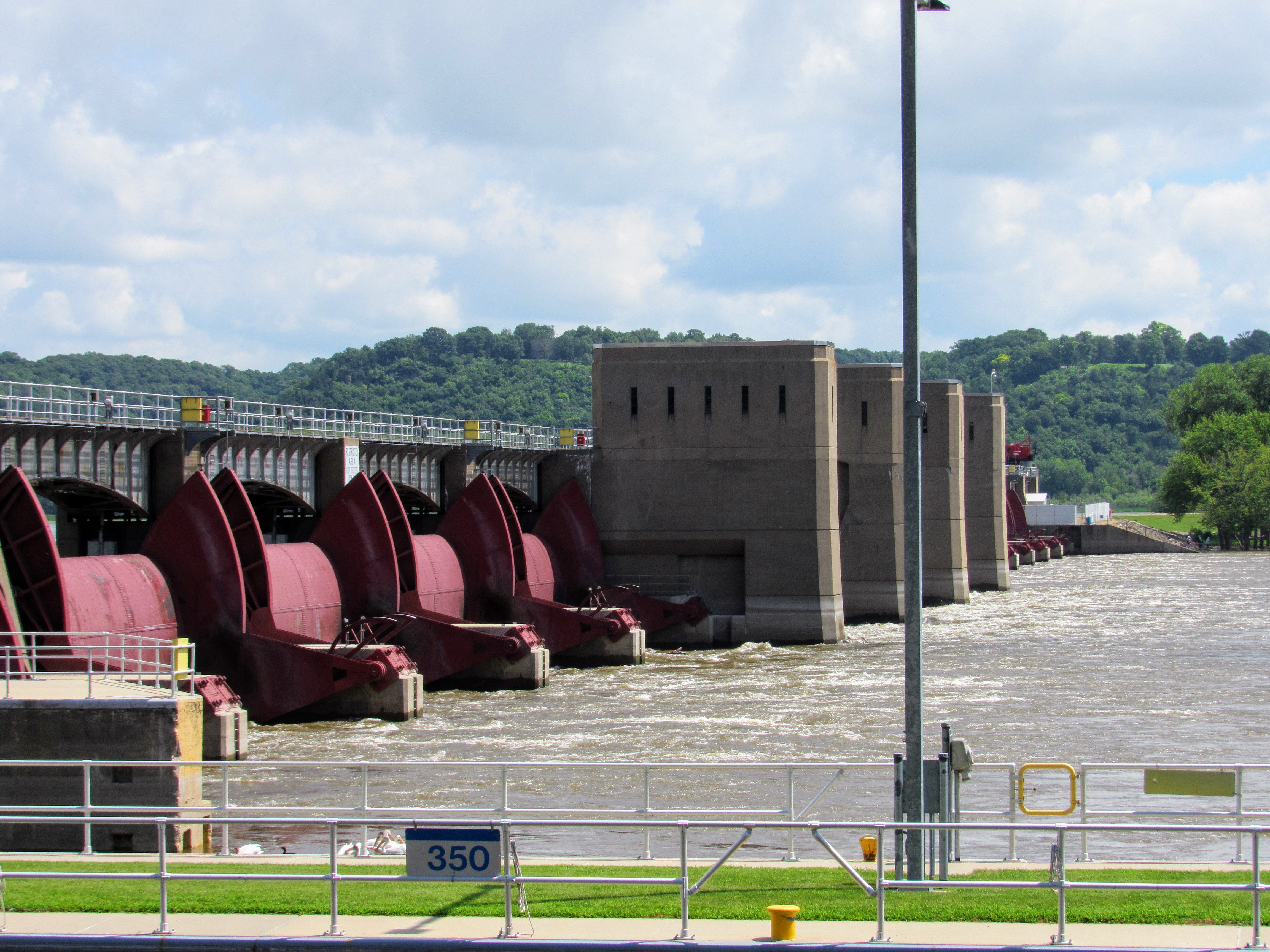 The movable dam at Lock and Dam #11 in Dubuque, Iowa is composed of 13 submersible Tainter gates. (Avery Gregurich)
This spring, when my mother called me, it was always to say that it was raining again, that they had closed the bridge into Missouri, that my brother still hadn’t planted his fields, and that she and my father were filling sandbags at the county fairgrounds. She likes to handle the shoveling, leaving my father to tie and toss the bags. The bags are taken by truck and laid up and down the river, my parents and everyone else trying to keep the edges of Illinois from washing away.
There, as everywhere along the Upper Mississippi, time stops when there are no barges moving. The barges help us keep time along the river, bringing the materials to plant a crop in the spring, and taking away whatever can be harvested in the fall. To see a tow and barges moving is to know that someone, somewhere, has purchased something, and that somebody else has just sold. If that isn’t the plainest illustration of an economy at work, I’m not sure what is.
Every town I stop in along the Great River Road, between Dubuque, Iowa and Rock Island, Illinois, advertises its historic intrigue, each one claiming a history that hasn’t ever gotten old. Renderings of historic steamboats fill the corners of nearly every Welcome sign I pass, when actually the river is more critical to these towns’ and the nation’s economy than it’s ever been. In the coming decades, traffic along the river is projected to grow even more, despite the fact that the locks and dams which make that traffic possible, are crumbling.
River towns have always been canvases. They used to be repainted by high water every few decades. Now, it seems like my mother and father are sandbagging every other year, and barges are tied up along the Mississippi’s shore for longer stretches of time each summer. The river has always supplied answers to ignored questions. If a comprehensive plan to repair or replace the locks and dams isn’t implemented and given funding soon, I have to wonder when something catastrophic will finally bring the state of this essential system to the national conscious.
At Lock and Dam #15, chains hang from the bottom of the Government Bridge, which connects Iowa and Illinois and extends over the lock. They’re called “last chance lines,” and if you’re on a vessel headed toward the dam, you can grab one and hang on until someone comes to out to rescue you.
Looking at them now, I have to wonder where the last chance lines for the locks and dams themselves are hanging, and just how long our current “fix-as-fail” approach can keep them off the horizon.
")
A tow headed north on the Mississippi River, just south of Lock and Dam #11 in Dubuque, Iowa. (Avery Gregurich)
")
The Cheryl Stegbauer locking through at Lock and Dam #15 in Rock Island, Illinois. In operation since 1896, this section of the Government Bridge must swing open for every tow that passes. The bridge also carries rail and auto traffic across the river. (Avery Gregurich)
")
The movable dam at Lock and Dam #11 in Dubuque, Iowa is composed of 13 submersible Tainter gates. (Avery Gregurich)
")
A deckhand watches as his tow locks through Lock and Dam #14 at LeClaire, Iowa, headed north. (Avery Gregurich)