Infrastructure in
America
Property, Pipes, and Improvement
The notion that land requires improvement because its inhabitants are also in need of civilizational uplift, and vice versa, is no accident of history.
—Brenna Bandhar1
Piped infrastructure, from oil pipelines to water pipes, is enabled in and through space, but also shapes the production of space. Property regimes—who owns or accesses property and by what legal, political, or customary arrangements—mold the trajectory of pipeline infrastructure and the distribution of resources held therein. The building and upkeep of pipeline infrastructure, in turn, affects the valuation and organization of land, property, and housing. These intimate and multidirectional relationships between property and pipes—between spatial production and resource production—are far from politically neutral. Given their origins in colonial regimes of “improvement” in many parts of the world, these relationships yield and are shaped by lasting social hierarchies related to race, ethnicity, caste, gender, and class, among other axes of difference.
Official narratives of urban improvement tend to stem from colonial logics of “civilizing” both property and person, yet in ways that harm and dispossess marginalized groups. Bangalore (officially “Bengaluru”) in southern India and Flint, Michigan, are two cities in which programs of improvement have shaped the geography of water infrastructure. While these two cities possess vastly different histories, early- and mid-twentieth-century logics of improvement, and the lasting effects on property, water infrastructure, and social difference, can be identified in both.
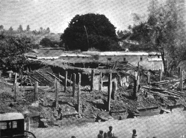
Picture of "native" house demolished in the aftermath of the plague due to colonial improvement measures in Bangalore (H Gordon, "A Plague Stricken City," The English Illustrated Magazine 22, no. 193 (1899): 17–23)
Colonial Logics of "Improvement"
Property is often essentialized as natural, legal, and inevitable—celebrated as a means to achieve freedom and autonomy. Yet as critical theorists have argued, this notion masks the violent, racial, and contested ways in which property comes into being as a bundle of relations that confer value through exclusion.2
For Karl Marx, the private enclosure of grazing, forest, and other common land across Europe starting from roughly the sixteenth century onward constituted “primitive accumulation”—an early boost needed for industrial capitalism to take root.3 Following from this, Marxist scholars such as E.P. Thompson have suggested that “improvement” provided the driving logic and rhetoric justifying the enclosure of common land and the making of private property.4 Improvement in rural areas entailed measures such as the removal of poorer landless peasants from common land, the demarcation of private property boundaries on common land, and the use of fertilizer and other scientific means to increase productivity. At the heart of improvement lies the belief that capitalist efficiency and value can only be achieved—and people civilized—via the introduction of private property rights, a process that in turn involves the seizure and enclosure of common land.
The ideology of improvement was carried forth to the colonies and transposed in violent and racial ways. As Brenna Bhandar defines it, the logic of improvement holds that “land that was not being cultivated according to European models of agriculture was waste, and capable of being legitimately expropriated.”5 And in a seminal essay, Patrick Wolfe argues that colonial invasion constitutes a “structure not an event.”6 By this he means that while the elimination of indigenous societies was core to settler colonial conquest, so too was the gradual erection of a “new colonial society on the expropriated land base,” or a set of structures premised on the usurpation and reorganization of land. In settler colonial contexts, land violently emptied of non-Christian natives and the ecologies upon which they depended was “discovered” by Europeans as terra nullius—that is, land owned by nobody and subject to appropriation by a ruling power. Upon this “expropriated land base,” European laws of improvement were adapted along explicitly racial lines, along with the sanctioned use of violence and taxation to enhance land value. In Thompson’s words: “Since labor (and improvement) constituted the right to property, this made it the more easy for Europeans to dispossess the Indians of their hunting grounds.”7
“Improvement” was applied in urban contexts as well. By the 1800s, European urban planners construed the city as synonymous with the overall aims of liberal government: individual liberty, dignity, and vitality secured through, among other things, private property, a relatively free market, and the limited reach of the state. With urban improvement, liberal government extended its control over life, or what Michel Foucault termed “biopolitics,” to control urban space and circulatory infrastructures such as water, drainage, and sanitation—an undertaking essential for the health of industrial capitalism and its workers. Inspired by the cholera prevention health experiments of Edwin Chadwick, improvement became the leitmotif for twinned sanitary and moral reform in Europe. Specifically, the improvement of European cities entailed slum removal, sanitary reform, and other measures related to the valorization of urban space, its people, and its circulatory infrastructures.
Transposed to colonial cities, urban improvement under European rule was inflected by the rule of colonial difference. If slum removal, sanitary reform, and other urban improvement measures in European cities entailed the stereotyping of working-class residents as immoral, criminal, and unhygienic, in colonial cities, such stereotyping also involved the deployment and reification of cultural hierarchies. In colonial cities across Africa and Asia, for instance, improvement invoked racial, ethnic, and caste hierarchies, in addition to class structures, to justify improvement measures. As Stephen Legg recounts in his work on the Delhi Improvement Trust, improvement measures in the early 1900s “sought to regulate not just the built form but also the biopolitical spaces of the urban form, from the street down to the individual.”8 This included the removal of poorer settlements and slums, stringent rules about the placement of drainage and pipes in urban neighborhoods, norms of western hygiene, the policing of street encroachments, and forced land acquisitions, all of which disproportionately targeted Delhi’s poorer classes and minorities.
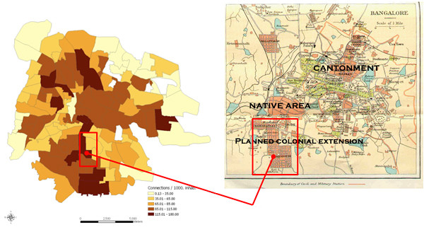
Maps of Bangalore showing (left) density of formal piped water connections in 2005 and (right) areas resulting from colonial urban improvement in the early twentieth century. Note that the areas that were improved also have a higher density of formal piped water connections almost one century later (BWSSB (left), John Murray, A Handbook for Travellers in India, Burma, and Ceylon (1924, right))
Unequal Pipes in the Post-Colonial City
Many colonial cities in India rolled out such improvement measures in the late 1800s and early 1900s by establishing “city improvement boards” to deal with what colonial planners saw as a problematic combination of slums, congestion, disease outbreaks, and political threats from working-class neighborhoods. In particular, the global outbreak of the bubonic plague pandemic in the late 1800s, which killed ten million people between 1898–1921 on the Indian subcontinent alone, prompted draconic city improvement measures. In the plague’s aftermath, working class slums became the target for demolition, forced vaccination, and removal. In Bengaluru, the logic of improvement was used to justify the removal of what were deemed to be “contagious” slums and to build new “hygienic” subdivisions at the city’s outskirts in the epidemic’s aftermath.9
Through improvement, the city developed circulatory water and sanitation infrastructures servicing new residential extensions that were built through eminent domain and other forms of state acquisition of peripheral land. Water conveyance technologies and modern dam projects—first, on the nearby Arkavathy river (early 1900s), and later, after that river dried up, on the more distant Cauvery river (mid 1900s)—enabled the pumping of water to select areas of Bengaluru, in the process bypassing villages and agrarian needs in the region.
Few of the displaced poor and working class could afford these selectively connected improved housing extensions, however. Colonial urban improvement boards did not invest significantly in affordable housing, nor in water and sanitation infrastructure extensions for the working poor. These spatial and infrastructural inequalities were not significantly addressed by post-independence urban planning and water agencies, and thus endure to this day. Many of the same laws and stipulations were inherited by post-colonial state agencies, including by the Bangalore Water Supply and Sewerage Board (BWSSB) and Bangalore Development Authority (BDA). Parts of the city that were originally planned as improved colonial extensions in the early twentieth century had a higher density of piped water connections provided by the BWSSB than other parts of the city even in the early 2000s.
As the city rapidly expanded its frontiers from the liberalization period (~late 1980s) and required more water, it also abandoned its local water harvesting and groundwater recharge sources, known as keres (which translates to “tanks”), in favor of piped water from the Cauvery river, thus compromising the region’s ecological sustainability. The peripheries of the city drew increasing numbers of lower class and lower-middle class informal residents, including poorer religious minorities and lower castes who self-built “unauthorized” subdivisions on lake beds, agricultural land, and forest land surrounding the city. Encroachments on lake beds and tanks was an outcrop of state-led projects of improvement, since in the early twentieth century, swamps and wetlands were considered sources of disease and were seen as wasted resources. State projects of improvement put wetlands to productive uses (farmland or private residential property), thus unleashing such flood-prone settlement by the urban public.
Without being able to evidence formal property arrangements, these informal settlers were excluded from formal piped water connections and had to turn to extra-legal mechanisms, including the use of water tankers or water “mafias.”10 In the early 2000s, informal residents were subject to neoliberal, market-oriented water reforms that had taken hold the world over whereby poorer informal residents had to pay considerable sums of money as entrepreneurial beneficiaries to receive corporatized water supply, with the justification being that such payments would “improve” the value of their properties. In the post-colonial city, colonial legacies of improvement continue to structure the unequal distribution of property and pipes. Programs of improvement and their resulting unequal formations of piped water infrastructure is not limited only to postcolonial cities in the narrow sense of the term “postcolonial.” Even post-industrial urban areas that have been historically and more recently narrated as “internal colonies,” as in the United States, exhibit the logics of improvement and their lasting effects on water and social difference.11
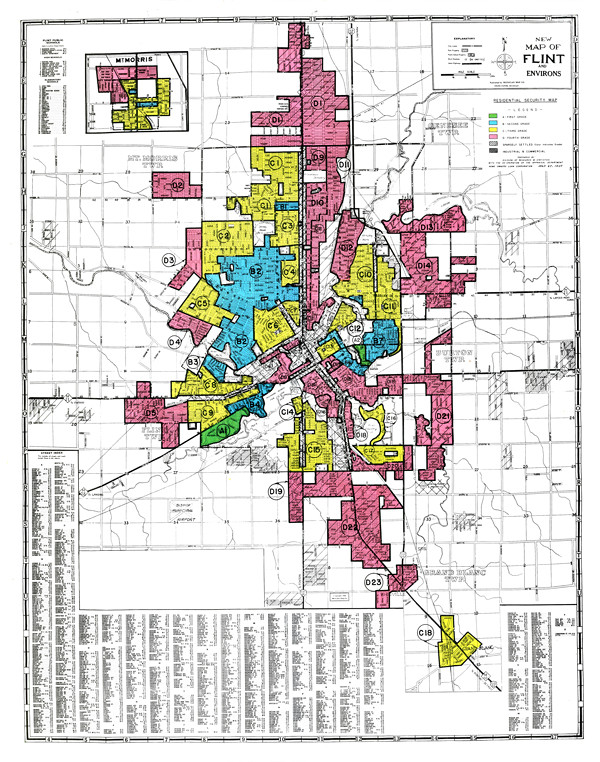
Home Owners Loan Corporation (HOLC) Residential Security Map for the City of Flint, 1934. (Robert K. Nelson, LaDale Winling, Richard Marciano, Nathan Connolly, et al., “Mapping Inequality,” American Panorama, ed. Robert K. Nelson and Edward L. Ayers, https://dsl.richmond.edu/panorama/redlining/#loc=12/42.9979/-83.6930&opacity=0.8&city=flint-mi&area=D14)
Poisoned Pipes in the Post-Industrial City
Black activists have long viewed the predicament of African Americans within America as a “nation within a nation.”12 In the mid-twentieth century, Black radical intellectuals and activists adapted the term “internal colonialism” from Latin American theorists to describe the condition of African Americans within the United States, thereby signaling radical solidarity with anti-colonial movements around the world. In his 1972 book, Racial Oppression in America, Robert (Bob) Blauner theorizes the ghetto as “a major device of black colonization,” with the police being a key agent of colonialism.13 Similarly, in the 1969 book Black Awakening in Capitalist America, Robert Allen argues that a program of domestic neocolonialism was advancing to contain Black rebellions in major cities across the country. In this lineage of thinking, the history of residential segregation in US cities—one of redlining, policing, and disinvestment from minority neighborhoods—is one that evinces this internal colonial logic. Such practices of racial segregation have had lasting legacies on property ownership and intergenerational wealth transfer, as well as on public health and equitable distribution of water infrastructure.
Flint, Michigan is a case in point. Its rule by an emergency manager—whereby democratic control was suspended, and under which the city was switched to contaminated water in 2014—has often been compared in the popular media to colonial rule.14 This act of internal colonialism cannot simply be understood as a more contemporary manifestation of neoliberal fiscal austerity. Rather, it is bound up in a longer history of internal-colonial improvement, one that I call “property making and taking.” This history is essential for explaining how the poisoning of its piped water infrastructure was decades in the making.
Briefly, when the Great Depression hit in the 1930s and devastated the city’s automobile and real estate industries, the Home Owners Loan Corporation (HOLC), a federal urban "improvement" agency, descended on Flint to revive the housing market. It was mainly tasked with acquiring foreclosed homes, refinancing home loans, and offering mortgage subsidies. But beneath this strategy lay an insidious logic of separating risky from non-risky, “colored” from “whites,” and undeserving from deserving. HOLC’s “residential security maps,” which were eventually replaced by the Federal Housing Administration’s (FHA) “redlining maps,” ranked mortgage risk by neighborhood on a descending scale from A to D, implicitly equating white neighborhoods with low risk (i.e., A and B) and Black and mixed-race neighborhoods with high risk (i.e., C and D).
Officially, HOLC agents were told not to mention racial demographics in their appraisals. However, their documents were replete with racially and ethnically coded language. Besides containing more decrepit homes and having poorer transportation and utility services, C and D areas were purported to be experiencing an “infiltration” of a risky and lower-grade population. Thus, given its Black industrial workforce and the fact that many whites had already started moving to the suburbs at the lure of developers, most of Flint was ranked high-risk (C and D).
If the HOLC set in motion inner city disinvestment and abandonment, the FHA sealed the color line from the 1930s–1970s by denying Black neighborhoods federally backed loans. Neighborhoods with Blacks in Flint in the 1960s were deemed “unquestionably slums” and thus ineligible for federal home insurance.15 As if the effects of the HOLC and FHA were not grave enough, Flint’s Black neighborhoods were targeted for slum demolition, blight removal, and highway building in the 1970s (which, needless to say, found strong footing among the town’s automobile lobby), all under the umbrella of “urban renewal.”
As Michael B. Katz documents, urban renewal has its roots in longer discursive and political projects of improving people and property.16 Yet, the question must always be asked: improvement to benefit whom? Logics of improvement in mid-twentieth-century America resulted in property-making favoring certain groups, while the property and personhood of others were criminalized, devalued, and free for the taking. In Flint, as in many industrial cities, this laid the groundwork for a water tragedy.
As property depreciation and ghetto formation surged, and was soon worsened by globalization, deindustrialization, and the loss of jobs in the late 1970s–1980s, whites (and many Blacks who could afford to) left Flint in droves by the end of the twentieth century. In the wake of this exodus, Flint was left with empty houses, boarded up stores, and weedy overgrown lots. Such property abandonment further spiraled disinvestment, ultimately laying the groundwork for infrastructural abandonment.
Looking back, the infrastructural abandonment of Flint following on the heels of property abandonment seems all but inevitable. When unelected emergency managers chose to cut infrastructural costs by switching its residents’ water supply from the Detroit river to the Flint river in 2014, they justified this move in the shrewd, neoliberal language of fiscal austerity. The Flint river was not afforded the same level of anti-corrosive treatments as the Detroit river, and thus led to the pipes’ heavy leaching of lead deposits into residents’ water systems. Emergency managers declared that Flint’s eviscerated property tax could not support a costly (and apparently life-supporting) water system. Through austerity discourse, Flint itself is framed and punished as if it were a financially reckless individual, while the structural and historical causes of its financial duress are thoroughly masked. Austerity affecting piped water infrastructure here is not race-neutral. Its conditions of possibility arise from racial property making and taking and the longue-durée logics of improvement in which they are embedded.17 Like the post-colonial city, legacies that shape the unequal distribution of property and pipes in Flint continue to haunt its contemporary urban land and waterscape.
To address the kind of water inequities witnessed in both Flint and Bangalore—both cities with vastly different histories, yet both exhibiting key relationships between property and pipes—property needs to be thought about otherwise. Following Andrew Sartori, how can property be “a plausible standpoint for the critique of domination and exploitation,” rather than simply the vehicle for continued domination?18 If much of contemporary infrastructure distribution is undergirded by unequal regimes of property, then how can such property regimes be disrupted, and perhaps decolonized, so as to forge more equitable, healthful, and life-sustaining infrastructural futures? There are no easy answers here. But in different corners of the world, the colonial workings of improvement projects are being laid bare, modes of possessive ownership are being rethought, and collective use and access to urban land and space is being insisted upon.
- 1Brenna Bhandar, Colonial Lives of Property: Law, Land and Racial Regimes of Ownership (Durham and London: Duke University Press, 2018), 181.
- 2See for instance Nicholas Blomley, “Law, Property, and the Geography of Violence: The Frontier, the Survey, and the Grid,” Annals of the Association of American Geographers 93, no. 1 (2003); Cheryl Harris, “Whiteness as Property,” Harvard Law Review 106, no. 8 (1993); Thomas W Merrill, “Property and the Right to Exclude,” Nebraska Law Review 730 (1998); Bhandar, Ananya Roy, “Paradigms of Propertied Citizenship: Transnational Techniques of Analysis,” Urban Affairs Review 38, no. 4 (2003).
- 3Karl Marx, Capital: A Critique of Political Economy, Volume I, First English Edition (Moscow: Progress Publishers, 2010 {1887}).
- 4E.P. Thompson, Customs in Common: Studies in Traditional Popular Culture (New York: The New Press, 1993).
- 5Bhandar, 120.
- 6Patrick Wolfe, “Settler Colonialism and the Elimination of the Native,” Journal of Genocide Research 8, no. 4 (2006).
- 7Thompson, 165.
- 8Stephen Legg, Spaces of Colonialism: Delhi's Urban Governmentalities (Malden: Blackwell, 2007), 175.
- 9Malini Ranganathan, “Rule by Difference: Empire, Liberalism, and the Legacies of Urban ‘Improvement’,” Environment and Planning: A 50, no. 7 (2018).
- 10Malini Ranganathan, “Mafias in the Waterscape: Urban Informality and Everyday Public Authority in Bangalore,” Water Alternatives 7, no. 1 (2014), http://www.water-alternatives.org/index.php/alldoc/articles/vol7/v7issue1/235-a7-1-6/file.
- 11Deborah Cowen and Nemoy Lewis, “Anti-Blackness and Urban Geopolitical Economy,” Society + Space, August 2, 2016, http://societyandspace.org/2016/08/02/anti-blackness-and-urban-geopolitical-economy-deborah-cowen-and-nemoy-lewis/.
- 12Charles Pinderhughes, “How ‘Black Awakening in Capitalist America’ Laid the Foundation for a New Internal Colonialism Theory,” The Black Scholar 40, no. 2 (2010), 71.
- 13Robert Blauner, Still the Big News: Racial Oppression in America (Philadelphia: Temple University Press, 2001 {1972}), 67.
- 14See for instance Juan Cole, “Flint and Gaza: Water Crises of Colonialism,” The Nation, February 3, 2016, https://www.thenation.com/article/flint-and-gaza-water-crises-of-colonialism/.
- 15Andrew Highsmith, Demolition Means Progress: Flint, Michigan, and the Fate of the American Metropolis (Chicago: University of Chicago Press, 2015), 47.
- 16Michael B. Katz, Improving Poor People: The Welfare State, the "Underclass,” and Urban Schools as History (Princeton: Princeton University Press, 1997).
- 17Malini Ranganathan, “Thinking with Flint: Racial Liberalism and the Roots of an American Water Tragedy,” Capitalism Nature Socialism 27, no. 3 (2016).
- 18Andrew S Sartori, Liberalism in Empire: An Alternative History (Oakland: University of California Press, 2014), 3.
 water pipeline transmitting water from the Cauvery river to the city of Bangalore (Malini Ranganathan)")
Bangalore Water Supply and Sewerage Board (BWSSB) water pipeline transmitting water from the Cauvery river to the city of Bangalore (Malini Ranganathan)
: 17–23)")
Picture of "native" house demolished in the aftermath of the plague due to colonial improvement measures in Bangalore (H Gordon, "A Plague Stricken City," The English Illustrated Magazine 22, no. 193 (1899): 17–23)
 density of formal piped water connections in 2005 and (right) areas resulting from colonial urban improvement in early twentieth century. Note that the areas that were improved also have higher density of formal piped water connections almost one century later. (BWSSB (left), John Murray, A Handbook for Travellers in India, Burma, and Ceylon (1924, right))")
Maps of Bangalore showing (left) density of formal piped water connections in 2005 and (right) areas resulting from colonial urban improvement in early twentieth century. Note that the areas that were improved also have higher density of formal piped water connections almost one century later. (BWSSB (left), John Murray, A Handbook for Travellers in India, Burma, and Ceylon (1924, right))
 Residential Security Map for the City of Flint, 1934. (Robert K. Nelson, LaDale Winling, Richard Marciano, Nathan Connolly, et al., “Mapping Inequality,” American Panorama, ed. Robert K. Nelson and Edward L. Ayers, https://dsl.richmond.edu/panorama/redlining/#loc=12/42.9979/-83.6930&opacity=0.8&city=flint-mi&area=D14)")
Home Owners Loan Corporation (HOLC) Residential Security Map for the City of Flint, 1934. (Robert K. Nelson, LaDale Winling, Richard Marciano, Nathan Connolly, et al., “Mapping Inequality,” American Panorama, ed. Robert K. Nelson and Edward L. Ayers, https://dsl.richmond.edu/panorama/redlining/#loc=12/42.9979/-83.6930&opacity=0.8&city=flint-mi&area=D14)