Infrastructure in
America
What to do with the Chicago River?
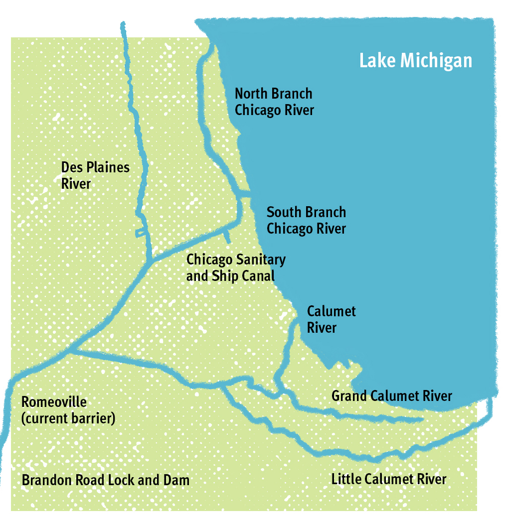
The Chicago River is not, strictly speaking, a river. It is a canal, straight and hard-banked, designed to keep the city sanitary and perpetually visited by ships. On Chicago’s north side, it can appear riverlike with painted turtles sunning on the rocks beneath restored parks and docks extending from urban homes. Downtown, a new riverwalk opens an oasis with boat rides and lively cafes. Heading south, the channelized river flows past skyscrapers and an open Chinatown park, then assumes its identity as receptacle for industrial waste with a southwestern turn into total linearity. The industrial corridor that defines the canal is surrounded by densely-populated neighborhoods with a high number of young people. They experience the canal as a dangerous, sometimes fenced-off place whose stinking fumes correlate with air saturated by factories and diesel trucks.
A short, shallow stream once dribbled into Lake Michigan, but Chicago’s ascent turned the river into a flush system for the offal and sewage generated by a budding metropolis. As meat-processing emerged, with up to nine million animals a year transformed into consumer products, the "open sewer" alongside the stockyards gained the name Bubbly Creek. In his expose of the dehumanizing conditions in the yards, Upton Sinclair described how "(b)ubbles of carbonic acid gas will rise to the surface and burst, and make rings two or three feet wide. Here and there the grease and filth have caked solid, and the creek looks like a bed of lava; chickens walk about on it, feeding."
Despite the visible pollution, by the mid-nineteenth century boosters had decided Chicago would become a regional capital. Located at the southern tip of Lake Michigan, the city asserted itself as a commercial gateway between European trade in the northeast and a western frontier opened by a quickly expanding railroad network. In his seminal text Nature’s Metropolis, historian William Cronon explains that goods made in Chicago could be easily exported because of Lake Michigan, the Erie Canal, and Hudson River. In turn, Chicago was a hub for imports.
At the turn of the twentieth century, disease and death caused by runoff into the Lake Michigan water supply undercut the successes of a metropolis primed to dominate in the nation’s urban hierarchy. To secure Chicago’s preeminence as a trading hub between the nation’s east and west, the city’s waste would have to be sent away. City planners approved the construction of a series of canals with the sole purpose of reversing the original direction of the Chicago River. In 1892, engineers used dynamite to blast through bedrock and set the course of the new waterway. Photographs show bomb-like eruptions pluming from the ground, men loading excavated rock onto hoppers, and the flint metal of compressed air rock drill.
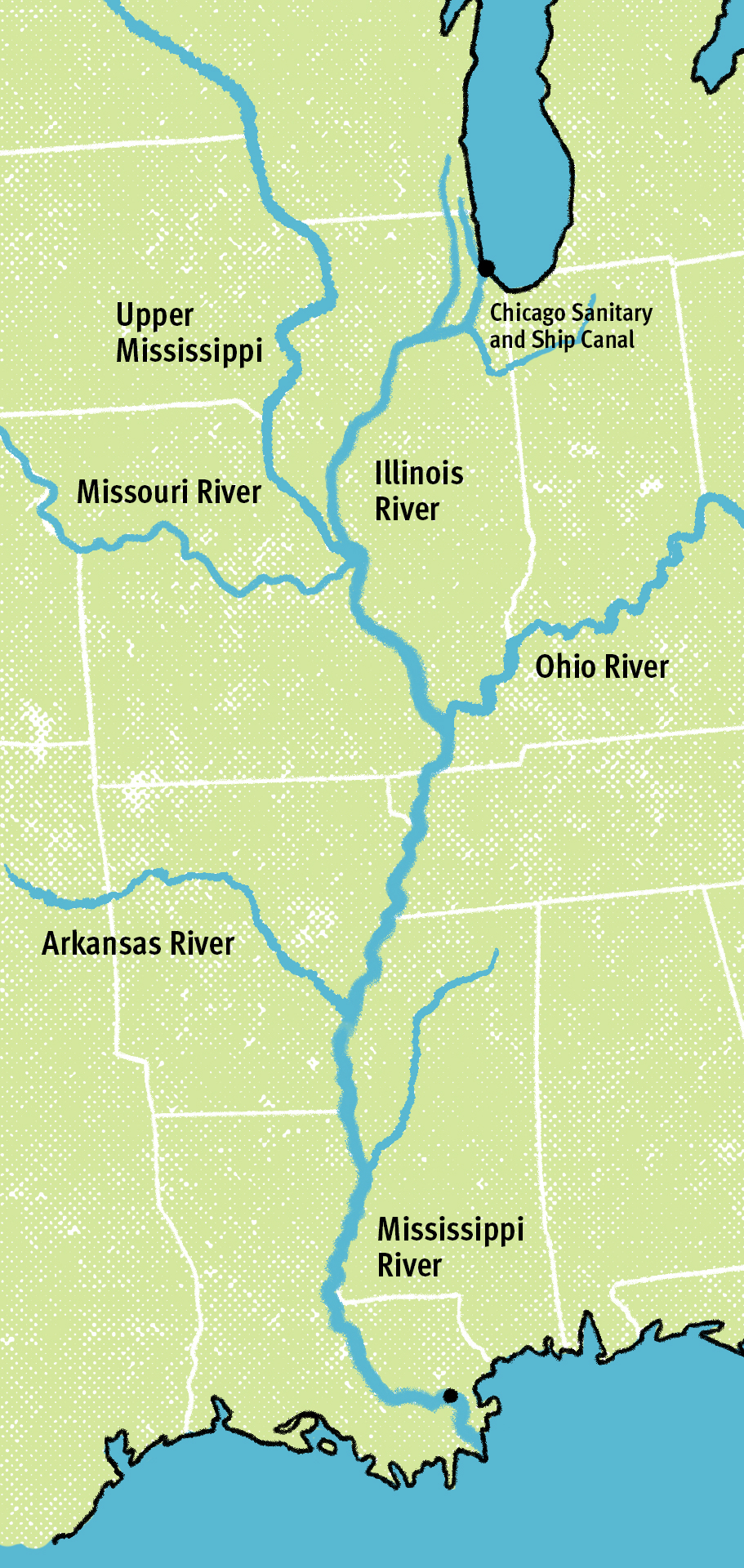
The goal was to leverage Chicago’s proximity to the subcontinental divide, letting gravity transform the stolid stream into an energetic canal flowing west to feed the Des Plaines, Illinois, and Mississippi Rivers, ending in the Gulf of Mexico. Like the canal itself, this mode of offshoring waste gained momentum, expanding into the Chicago Area Waterway System (CAWS) between 1907-1911 and embedding market relations into the very infrastructure of the city.
But is it waste or wastes that course through the canal? It’s not just a matter of grammar. Chicago sewers blend rain with domestic drains and factory wash in subterranean tunnels and quarries transformed into reservoirs. The dirty secret is called Deep Tunnel, a project begun during a last gasp of federal funding in the 1970s and slated to reach completion in 2029. Chicago’s Deep Tunnel – the world’s biggest – holds the watery blend beneath the city and at its margins in order to stagger the flow to treatment plants, where it is disinfected prior to its southward migration.
The Deep Tunnel aims to keep Chicago above water during increasingly frequent rain events. (A rain event—a feature of climate change in the Midwest—differs from a rain storm in that precipitation falls in an abbreviated time period and overwhelms the built environment.) During rain events, the water overwhelms sewers, whose contents overflow into streets and waterways as a result of malfunction known as combined sewer overflows. Some have pointed out the problem stems from categorizing rain as waste and then mixing it with drains until it becomes so. They urge Chicago to separate sewers from storm drains. But Deep Tunnel fever has seized the world with the logic that rising water can be held at bay. At a price tag of 3.8 billion dollars, one wonders why the water held in the Deep Tunnel is still treated as refuse.
Humans experience distinct forms of waste whose toxicity varies according to race and social class. The wealthier you are the less waste you confront, despite the fact that you likely generate more through higher levels of consumption. The bulk of the world’s toxic remains are directed toward low-income communities of color. This is equally true along the river system that carries Chicago’s wastewater into the Gulf of Mexico. North prevails over South at numerous scales: the gleaming Chicago Riverwalk vs. the stagnant pools of industrial runoff that cut into neighborhoods to the south; the ultraviolet disinfection at a north suburban treatment plant vs. sludge drying at southern plants; Saint Louis’s failed Supreme Court bid to prevent Chicago from flushing in their direction; and the dramatic quality difference between source water from Lake Michigan and the New Jersey-sized dead zone in the Gulf of Mexico. As they run south, the Illinois and Mississippi Rivers pick up more point-source pollution and sewage along with the unregulated runoff of fertilizer and pesticides from American farms. The commingling spikes nitrogen and phosphorous levels and feeds green cyanobacteria that bloom into lethal, oxygen-sucking algae.
Because the Gulf dead zone isn’t talked about much up north, the infrastructure can be said to function as it was intended. After a hundred and twenty years, even the most engineered waterway can feel natural, inevitable. But in light of climate change, this forged connection between the Great Lakes and Mississippi watersheds has a renewed visibility—and urgency.
(David Wilson)
Recently, Great Lakes states have been eyeing the canal—not out of concern for floods or the endpoint of Chicago’s waste, but because of four species of fish. Labeled “bio-invaders” and “Asian carp,” these fish were first imported to the U.S. as a natural form of pollution control and later released into the Mississippi watershed in the 1980s. It was widely assumed that the fish would quickly die in unfamiliar waters, but the carp proved highly adaptable. They outcompeted other fish in terms of both consumption (of food) and proliferation (of progeny). In contrast with fish like smallmouth buffalo, who pick feed out of the environment, big head and silver carp open their mouths and swim. Imagine an enormous vacuum cleaner pulling up a single object.
“A vacuum cleaner isn’t a bad comparison,” James Garvey, a zoologist at Southern Illinois University said. Garvey described a sieve of fine bones, called raker gills, that allow carp to filter as they suck water through. The carp have a specialized diet of plankton, and a whole lot of it. They disrupt the food chain, starving out the many species who also depend on plankton in their diet. This occurred in the Mississippi, where the carp dominate the register of species, and in parts of the Illinois River, where their long-distance swimming ability has also allowed them to flourish. Because the Chicago Sanitary and Ship Canal fuses the rivers to the Great Lakes, people on their shores are bracing for the carps’ arrival.
Not everybody agrees on how close the carp are to Lake Michigan. Many in downstate Illinois hold that commercial fishing and the Army Corps of Engineers adequately manage carp movement, and that their threat is exaggerated. But turn to Great Lakes commercial or sport fishermen and you will hear a plaintive call to protect a way of life and a $7 billion-dollar a year industry. People across the Great Lakes basin frame a carp influx as an imminent danger that could thwart the region’s watery revival, and advocate sealing off paths of entry.
Should they enter the lakes, the carp would likely out-eat beloved species like trout, sturgeon, and walleye, especially as increased flooding warms Lake Michigan and fuels algae blooms—a delicacy for carp. But the fear tracking carp movement has done little to stop them. How we talk about carp may even produce the wrong set of solutions. Stressing the invasion of a foreign, fertile multitude evokes current immigration rhetoric and the desire to build a wall in water. Media heighten the sense of war, which triggers military solutions like costly barriers. Perhaps more disorienting, they direct us to the symptom and not the cause—as if animals and plants conspired to overtake ecosystems, rather than being carried along routes of exchange. The talk of infestation, bio-invasion, and demographic threat obscures the fact that the transnational movement of commodities first introduced foreign species and continues to facilitate their travel; the backend of global capitalism teems with life.
In 2002, electric cables were strung across the Chicago Sanitary and Ship Canal (CSSC) at Romeoville Lock and Dam to stem the tide of carp. Then, in 2004, the USACE added a more formidable network of steel electrodes. Coming in at a price tag of $9 million, their scale and technical sophistication were hailed as an engineering marvel. But by 2009, the effectiveness of the barriers was brought into question. By 2011, the USACE added two more barriers, spanning twenty-five feet and extending across the CSSC at a hundred and sixty feet wide. Meanwhile, Environmental DNA monitoring, which tests for the genetic presence of carp, picked up traces of silver and big head carp DNA in the Great Lakes basin.
Amid concerns about the four Romeoville barriers, the Army Corps of Engineers proposes another barrier, euphemized as a high-tech “suite” of solutions. In truth, it largely involves underwater cables that create an electric current, and carries a price tag of over eight hundred million dollars. In an interview, Robert Hirschfeld, a water policy specialist at Prairie Rivers Network, a nonprofit water advocacy group in Illinois, said, “This solution is militarized and puts the army in charge of the river. It builds defenses, metaphorical and literal. Build a wall, reinforce it, and electrify it. When we narrowly define the problem, we get a narrowly defined solution.”
Barriers aren’t the only proposed solution. “The goal originally was separation of the Great Lakes and Mississippi watersheds,” Hirschfeld said. This was the objective shared by many environmental organizations and advocacy groups in the Great Lakes region, including the Great Lakes Commission and the Great Lakes and St. Lawrence Cities Initiative. In 2010, the two organizations worked jointly to release a report that evaluated the engineering possibilities of physically separating the basins. The report not only recommends separation, but also argues that restoring the natural divide is both technically feasible and the only way to permanently prevent Asian carp and other invasive species from reaching the Great Lakes.
One major player opposed to the general disposition of the 2010 Restoring the Natural Divide report is the barge industry. Publicly, the barge industry, which uses the canal more than most, dismisses the imminent threat of the carp. It threw maximum weight behind opposing separation of the basins. When the Army Corps prepared to file its 2017 recommendations for bolstering the carp barrier at the Brandon Road Lock and Dam, shock reverberated among USACE ranks that the Trump White House put a hold on its release. In his book, The Great Lakes Water Wars, journalist Peter Annin notes how Illinois Lieutenant Governor Evelyn Sanguinetti, a Republican, wrote a Chicago Tribune op-ed calling on the White House to delay release of the Corps’s report and then the White House did so. Sanguinetti and then Illinois Governor Bruce Rauner were part of a cohort of Midwest Republican governors closer to industry than to other governmental bodies. Newly appointed Vice President Mike Pence, who as Governor of Indiana had also numbered in this cohort, seems to have heard Sanguinetti’s call and advised shelving the report. Many of the barges that ply the canal originate in Pence’s home state. Sixteen Republican members of Congress gave voice to the barge industry in a letter to Trump, asking for the report to wait until the newly minted Republican Senate confirmed a new Army assistant secretary responsible for overseeing the Corps of Engineers.
Had a silver carp not cleared the existing barrier in June 2017, the report might never have seen the light of day. The single fish reminded the U.S. Senate Appropriations Committee how easily boundaries can be crossed, so the committee forced the White House to release the report five months after the intended date. The USACE’s recommendations continue to meet with resistance from the barge industry. Seven Democrats and all the Republicans voted against H.R.2740, a June 2019 House of Representatives appropriations bill, that provides the corps with potential funds for work on the barrier. It passed 226 to 203 despite $108,500 in campaign contributions given to the representatives who voted against the appropriations bill by the American Waterways Operators, which represents the barge industry. The barge industry’s logic insists that anything slowing barges will hobble the economy.
(David Wilson)*
The barge industry turns American rivers into a kind of fossil fuel pipeline. In the 1980s, some seventeen million tons of commodities were shipped out of Chicago alone, with a notable increase at Lockport, where that number expanded to thirty-six million. Barges were mostly carrying sand and concrete out of the city, but oil, corn, and grain comprised a large part of the cargo. By the beginning of the twenty-first century, the main purpose of the barge industry was the transfer of gasoline and oil around the Chicago area. According to analysis by the Chicago Metropolitan Association for Planning, by 2012, the barge industry moved fully 9,785 kilotons of coal along the CAWS, illustrating an increase of 12.5 percent since 2007, when coal, still the primary commodity, came in at 8,695 kilotons.
Despite the increase in petroleum shipments by barge in the nineties, overall freight transport along the CAWS as a whole declined. Currently, damaging levels of Manganese have largely replaced coal transports amidst the general downturn in demand for barges. A 2015 NRDC policy brief reported that "waterborne shipping in recent years has accounted for only about 3 to 4 percent of total tonnage and 0.3 percent of freight value moving through the Greater Chicago region." Meleah Geertsma, the author of the brief, maintains that "There’s a way to talk about how we move goods without causing increasing damage to residents, roads, and waterways. But the barge industry isn’t interested in those conversations."
The direct and indirect costs of the canal are mounting: around $1.7 billion to subsidize the barge industry, $13,943,000 million to operate the Romeoville barrier, $831 million proposed for the Brandon Road Lock and Dam. And with Climate Change, its warming rains and floods, the costs incurred by utilizing the contents of barges remain largely incalculable. As it resists plans large and small, the barge industry insists that its cargo simply must move. However, the region’s pipeline network and trucking capacity are both undergoing substantive expansion, and most waterborne shipping occurs south of the Lockport Dam; if the stuff must move, then there seem to be multiple routes available to industry.
The lines between private industry, the federal government, and the public aren’t as clear as you might imagine. Although it accrues no profit, the Army Corps of Engineers is invested in the flow of trade along American waterways. The recommendation on Brandon Road fulfills its charge to mitigate the spread of invasive species, but the USACE consistently forefronts protection of the barge industry in its proposals. The public subsidizes the liquid corridor, along which petrochemicals travel, to the tune of 90%. Of the funds allocated to operating the locks and dams in 2016, for example, $1.7 billion burdened the taxpayer, with the barge industry chipping in only $75 million. “That’s million with an ‘m,’” Hirschfeld said. “The barge industry only exists because of public subsidies.”
If the canal were to be closed to ships and carp, then what of its sanitary function? One option would be for Chicago to recycle it. The recycling of water for use in industry and agriculture is already practiced in water-scarce countries. The Great Lakes watershed cannot be called water-scarce, but there are parts of Illinois and elsewhere in the Midwest where aquifers buckle under the strain of development and farming. A water recycling plant treating and redistributing the contents of Deep Tunnel could also reduce flooding across the region. The Deep Tunnel and Stickney Wastewater Treatment plant are the largest of their kinds, so it stands to reason that they might be coupled, in typical Chicago hyperbole, with the world’s largest water recycling plant.
The reimagining of Chicago’s wastewater might allow the canal to look more like an urban river and invite additional restoration. Fawn Pochel, Education Coordinator at Chicago’s American Indian Center, speaks of how “the river system has always been used as a lifeline for Indigenous trade and travel. It’s also served as a way to connect families and kinship networks throughout the region. People view themselves as related to the river. It sustains life and livelihood. The waters were used as a form of drinking, which we don’t see anymore. Rivers were used to cultivate food and medicine, not just as a highway.” Knowledge of the food and medicines that can grow along these waters, how they can be used as modes of connection, and how the rivers can support life continues to be transmitted in Indigenous communities. Pochel sees an analogy between “how we imprison the water in concrete foundations and how we have imprisoned Indigenous people on reservations.” Scaling back the violence visited upon one could allow the other to initiate healing.
Artists Sarah Lewison and Andrew S. Yang also envision reciprocal healing in their project to “Eat the River, Heal the River” that reclaims carp as the “Midwest Superfood.” Recognizing that most fish in contemporary waterways have been introduced, they focus on the high omega-3 flesh of the silver and big head carp and that they are caught in the wild, not farmed. Many environmental advocates oppose building a sustainable industry around carp, an unwelcome fish that currently poses risks to the Great Lakes. But Lewison and Yang contend that learning to live in an era of climate change demands that we reimagine how we inhabit, and eat from, our watershed.
In reconceiving the fish, Lewison and Yang spent time at two Kentucky carp processors. Where Two Rivers Fisheries exports the fish to Chinese markets where it is a delicacy, Fin Gourmet looks to “bring things that have been marginalized in our culture and ecology back to the center.” Fin Gourmet’s founders practice restorative justice by hiring staff recently released from prison as they acclimate Americans to eating from their watersheds. In this way, they hope to repair larger ecological and social systems. Over a meal of carp filets served up to a banquet of two hundred people, Lewison and Yang remarked, “everything is starting to belong everywhere. Thinking about how to best relate to other species is about moving away from the whole schema of the ‘invasive,’ ‘alien’ or ‘non-native.’ We can’t eradicate the fish, so we must cooperate.”
Financial support for the research conducted in this article was provided by a Humanities in a Changing Climate Grant from Humanities Without Walls, a consortium funded by a grant from the Andrew W. Mellon Foundation and based at Illinois Program for Research in the Humanities.
*Correction: a map with an earlier version of this story mislabeled the Arkansas and Missouri Rivers.
")
A boat moves down the south branch of the Chicago River (Lloyd DeGrane)
")
(David Wilson)
*")
(David Wilson)*